Planning for Sea Level Rise in Olympia, Washington
Photo attributed to Drums600. This work has been released into the public domain by its author. No endorsement by licensor implied.
Posted by
Kirsten FeifelProject Summary
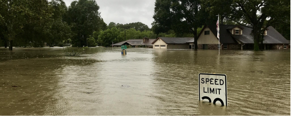
The relatively low elevation of downtown Olympia, Washington, makes it prone to flooding due to sea level rise. To assess the city’s vulnerability, flooding maps were produced for a variety of sea level rise scenarios. Olympia’s propensity for and duration of flooding varies with the amount of sea level rise projected. As a result, city planners have developed adaptation strategies that could reduce the vulnerability of downtown Olympia.
Background
Lower downtown Olympia sits on reclaimed land created with hydraulic fill within Budd Inlet, a tidally-influenced southern arm of Puget Sound. On average, downtown Olympia is 18 to 20 feet above sea level. During extremely high tides, however, the water can reach 18 feet, making the water’s edge mere feet from downtown buildings at times. Due to its tenuous location, Olympia considered the potential effects of sea level rise initially in 1993 and released the Preliminary Assessment of Sea Level Rise in Olympia, Washington: Technical and Policy Implications. The report covers sea level rise projections as they were known at the time, potential impacts to Olympia, and presents some strategies and policy options. In 2007, there was a renewed drive by the City Council to plan for the effects of sea level rise after they realized the site selected for the new City Hall could be prone to flooding if sea level rose. In 2009, the Climate Impacts Group released The Washington Climate Change Impacts Assessment, which provided updated regional sea level rise predictions varying from 2 to 50 inches by 2100.
In 2014, the city updated their comprehensive plan to include sea level rise considerations. The plan stresses the redevelopment of downtown Olympia and considers climate change impacts on these efforts. While flooding is still a priority, the plan also takes into consideration sea level rise impacts on utilities. A major goal was to develop and implement a sea level rise management plan that would protect downtown Olympia. In March 2019, the city released the Olympia Sea Level Response Plan, which includes strategies for adaptation planning and governance.
Implementation
To assess the impacts sea level rise could have on downtown Olympia, the city invested in high-resolution LIDAR elevation data and used the LIDAR maps to run flooding simulations during high tides and storms at 0.5 ft incremental increases in sea level relative to its current level. Maps were produced to assess areas flooded, duration of flooding, damage and interference with existing infrastructure (e.g., wastewater treatment plant, sewage pump station), and interactions with piped streams/large stormwater culverts. The city also invested in geological monitoring equipment to monitor land subsidence or uplifting and plans to install local tide gauges.
Olympia has multiple stormwater outfalls designed to transport precipitation from the streets of downtown Olympia into Budd Inlet. If a 0.5 ft increase in sea level rise were to occur, marine waters could infiltrate existing stormwater pipes during the two highest tides of the year. The marine waters could be transported in the stormwater pipes and discharged onto the streets of Olympia, resulting in ponding on some streets and temporary flooding of low-lying structures. With a 1 ft increase in sea level, some stormwater pipes are projected to be inundated with marine waters and unable to transport waters from the streets of downtown to Budd Inlet, causing an increase in flooding area and duration in downtown Olympia. A 2.5 ft increase in sea level could cause Budd Inlet to overtop its banks and flood most of downtown Olympia. In parts of downtown Olympia the wastewater system is combined with the stormwater system. Higher sea levels could compromise the integrity of the system when marine waters flood the pipes, potentially exceeding the capacity of Olympia’s wastewater treatment facility and causing wastewater contamination.
A piped stream bisects downtown Olympia and discharges into Budd Inlet. The pipe frequently runs at capacity during winter storms. Simulations indicate that the existing system can handle a 0.5 ft increase in sea level rise during an average tide and average storm. However, if there is a 1 to 2 ft increase in sea level, an extremely high tide and heavy rainfall, the volume of water in the pipe could exceed capacity, causing prolonged flooding in parts of downtown Olympia.
To address these potential impacts, the City of Olympia Public Works Department, the Port of Olympia, and LOTT Clean Water Alliance (a wastewater management service in Lacey, Olympia, Tumwater, and Thurston County) are working together to implement the Olympia Sea Level Rise Response Plan. The plan includes a variety of near-, medium-, and long-term strategies (e.g., living shorelines, raised walls, elevated boardwalk, backflow prevention for outfalls, design standard updates) organized by type, phasing, and focus area. Priorities include coordinating emergency response, installing stormwater tide gates, and refining and implementing the sea level rise and flooding monitoring strategy. The city is also working to increase the resilience of the Budd Inlet Treatment Plant by increasing flood storage and pumping capacity for redundancy, floodproofing sensitive facilities, and elevating upgraded or new infrastructure components above projected flood levels.
Outcomes and Conclusions
The City of Olympia is proactively considering the impacts of sea level rise by using models to simulate downtown flooding. The city has also taken steps toward adaptation action through its sea level rise response plan, attributing success in adaptation planning to their work with community members on climate issues and local partnerships. Challenges the city faces include finding appropriate funding for implementation and managing coordination between agencies. Currently, there are no plans to abandon or relocate infrastructure in downtown Olympia to an area that is less prone to flooding due to sea level rise. In fact, a city ordinance was passed calling for the rejuvenation of downtown Olympia, the heart of the city. Thus, city planners are focused on strategies that will reduce the vulnerability of downtown Olympia to sea level rise.
Citation
Feifel, K. & Braddock, K.N. (2021). Planning for Sea Level Rise in Olympia, Washington [Case study on a project of the City of Olympia’s Public Works Department]. Version 2.0. Product of EcoAdapt’s State of Adaptation Program. Retrieved from CAKE: https://www.cakex.org/case-studies/planning-sea-level-rise-olympia-washington (Last updated October 2021)
Project Contact
Susan Clark
Senior Planner
[email protected]
City of Olympia – Public Works Department