Sector Addressed
Conservation / Restoration
Development (socioeconomic)
Disaster Risk Management
Land Use Planning
Tourism / Recreation
Water Resources

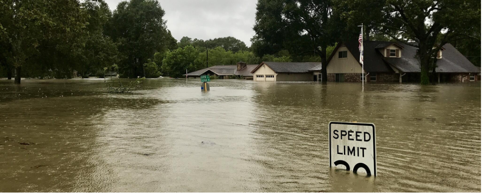
Photo attributed to Mike DelGaudio. Incorporated here under the Creative Commons Attribution 2.0 Generic license. No endorsement by licensor implied.
The Maryland Department of Natural Resources (DNR) is a lead agency in the state with respect to climate change, playing an essential role in the development and implementation of the Maryland Climate Action Plan. Phase I of the plan focused on key strategies to reduce Maryland’s vulnerability to sea level rise and coastal storms. One of the recommendations in the report was to establish new criteria for land acquisition based upon climate change vulnerability. DNR has implemented this recommendation through the GreenPrint and Coastal Atlas visualization decision support tools. DNR is actively working to assess sea level rise vulnerability, develop adaptation opportunities, and strategically conserve land along Maryland’s coastlines.
Maryland has over 3,000 miles of coastline with the majority of the coastal zone experiencing naturally occurring land subsidence. The low-lying, sinking coastal areas make Maryland uniquely vulnerable to the effects of sea level rise. During the last century, Maryland experienced a relative sea level rise of a foot—twice the global average—in part due to land subsidence. In 2000, the Maryland Department of Natural Resources (DNR) released A Sea Level Rise Response Strategy for the State of Maryland. This preliminary report reviewed the sea level rise literature and associated research, identified vulnerability, and assessed Maryland’s existing response capabilities.
Maryland has since been a progressive leader in planning for the effects of climate change. In 2007, DNR was selected to chair the Adaptation and Resiliency Work Group, which produced two reports: 2008’s Phase I: Sea-level rise and coastal storms (Chapter Five of the Climate Action Plan) and 2011’s Phase II: Building societal, economic, and ecological resilience. The reports detailed Maryland’s vulnerability and proposed policies to enhance the state’s resilience. Among these recommendations were the strategic identification, acquisition, protection, and restoration of high-priority lands that are likely to support resilience.
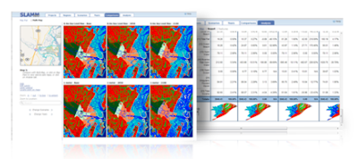
To address the recommendations outlined in the Climate Action Plan, DNR pioneered a green infrastructure assessment mapping tool called GreenPrint to assess the relative ecological importance of every land parcel in the state. GreenPrint uses GIS software to create color-coded maps of information layers and aerial photographs to help land managers implement conservation strategies and identify land acquisition priorities. The GreenPrint tool allows DNR to select ecologically valuable lands, or “Targeted Ecological Areas” (TEAs), and designate them as conservation priorities. A new layer of information was added to indicate climate vulnerabilities and adaptation opportunities, such as areas of TEAs likely to be inundated by 2050. Additionally, GreenPrint includes an evaluation tool that allows DNR, land conservation partners, and the public to conduct evaluations for any parcel in the state. As part of the evaluation, GreenPrint generates a scorecard that systematically quantifies the conservation and climate adaptation benefits of a parcel of land relative to others.
Building off of GreenPrint’s success, DNR identified priority Wetland Adaptation Areas (WAA) where wetlands will likely migrate inland as sea level rises. WAAs and other adaptation targeting methods are described in Coastal Land Conservation in Maryland: Targeting Tools and Techniques for Sea Level Rise Adaptation and Response and visualized on DNR’s Coastal Atlas. Coastal Atlas is intended to be used by decision-makers to visually analyze Maryland’s available coastal and ocean data for planning, and includes detailed layers of recreational use, habitats, shoreline erosion rates, and sea level rise vulnerability. Coastal Atlas also includes a series of case studies or “map stories” that highlight DNR’s resilience, land conservation, and working waterfronts projects. These stories include lessons learned, project methods, up-to-date maps, and specific on-the-ground examples. The DNR Land Acquisition and Planning Unit uses the Coastal Atlas to screen and evaluate potential land acquisitions based on climate change considerations (e.g., sensitivity and exposure to impacts such as sea level rise and storm surge; adaptation and mitigation potential).
Targeting and evaluation tools such as GreenPrint and Coastal Atlas help DNR review state conservation easements and acquisitions for site-level attributes that support climate adaptation objectives, such as storm surge abatement and restoration opportunities to increase coastal ecosystem health and/or the carbon sequestration potential. DNR targets and acquires coastal land parcels that are vulnerable to sea level rise and coastal erosion as conservation easements. Coastal landowners may also request targeted resilience plans for their properties that recommend best practices to reduce coastal hazard risks and increase resilience of coastal habitats.
The Maryland DNR incorporates climate change into its conservation and restoration programs by targeting the acquisition and protection of critical lands that will likely provide adaptation and/or mitigation benefits. DNR also actively supports complementary activities such as the implementation of the Coast Smart Construction Program, which requires state agencies to consider sea level rise and coastal flooding impacts in the siting and design of all capital infrastructure projects, and the development of Maryland’s Plan to Adapt to Saltwater Intrusion and Salinization, which identifies research needs and priorities to protect agricultural lands, wetlands and coastal forests, surface waters, and aquifers.
The key to Maryland’s success in adaptation planning has been the knowledge base that has been built over the past few decades. Research programs have been targeted to support and build off of one another as new results are returned. Maryland has dedicated, long-term staff who continually remind leadership of the potential effects of climate change, renewing the motivation to promote and mainstream climate change adaptation into policies and procedures.
Feifel, K., Papiez, C., Braddock, K.N. (2021). Integrating Climate Change Adaptation Strategies into Maryland's Coastal Land Conservation Targeting [Case study on a project of the Maryland Department of Natural Resources]. Version 2.0. Product of EcoAdapt’s State of Adaptation Program. (Last updated August 2021)
Matt Fleming
Director
Department of Natural Resources
Chesapeake & Coastal Service
[email protected]
Christine Conn
Director, Office of Science and Stewardship
Department of Natural Resources
Science, Stewardship and Assessment
[email protected]
Catherine McCall
Division Director
Department of Natural Resources
Coastal and Marine Assessment
[email protected]